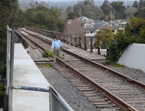
Residents discuss options for the rail trail from Live Oak to Seacliff at a meeting April 13 at Live Oak Elementary School. Mike Sherrod, a principal at RRM Design Group, points to part of a proposed design. (Stephen Baxter — Santa Cruz Local)
LIVE OAK >> Santa Cruz County planners have described options for the rail trail from 17th Avenue in Live Oak through Capitola to State Park Drive in Seacliff.
The details were described in an online workshop April 6 as well as at a meeting at Live Oak Elementary School on Wednesday, April 13.
As with Segment 9 through Santa Cruz and part of Live Oak, the plans for Segments 10 and 11 include “interim” and “ultimate” options.
- An “interim” plan aims to temporarily remove the train tracks and build a path on the rail line, county planners said. View plans for the interim path in Segments 10 and 11 in Live Oak, Capitola and Seacliff.
- An “ultimate” plan would keep the rail track and build a path next to it. View plans for the ultimate path in Segments 10 and 11 in Live Oak, Capitola and Seacliff.
An environmental impact report for the two versions of the rail trail is due at the end of the year.
Santa Cruz County planners have launched an online survey with detailed maps to gather feedback on how both designs could be improved. The survey will be available at least through early June, said Santa Cruz County Project Manager Rob Tidmore.
“My hope is that people will look at both designs with a critical eye and tell us how we could improve the trail to meet their needs regardless of whether the ultimate or interim trail is built,” Tidmore wrote in an email Friday.
“You’ll notice that we’re not asking whether people prefer the ultimate or the interim trail, this survey is not the place to give that feedback. The political debate over what to do with the trail has unfortunately overshadowed meaningful discussions about the design of either [ultimate or interim] alignment,” Tidmore wrote.
“What people should know is that it’s very likely we’ll be moving forward with one of these alignments or some combination of the two, so let’s focus our energy now on making them both as good as they can be,” Tidmore wrote.

Santa Cruz County Project Manager Rob Tidmore, center, talks to residents about plans for the rail trail on April 13 at Live Oak Elementary School. (Stephen Baxter — Santa Cruz Local)
Tidmore asked residents to consider:
- Are there important connections to or from the trail to your neighborhood that have been left out?
- Are there design features you want to see or avoid?
- Do you want to use the trail at night? How could the trail be made safer at night?
- Are there features of one alignment that should be replicated in the other?

Planners have described an “ultimate” plan with a path next to the railroad tracks. On Segment 10 from 17th Avenue in Live Oak to 47th Avenue in Capitola, it is “generally 12 feet wide but reduced in some areas to navigate some constraints,” said Rob Tidmore, Santa Cruz County project manager, during an April 6 public workshop. (Santa Cruz County Regional Transportation Commission)

Planners have described an “interim” plan with a path on the rail line. On Segment 10 from 17th Avenue in Live Oak to 47th Avenue in Capitola, it is “generally 16 feet wide,” said Rob Tidmore, Santa Cruz County project manager. “But just like the other alternative, it is reduced in some areas to 12 feet to navigate constraints.” (Santa Cruz County Regional Transportation Commission)
Segment 10: 17th Avenue in Live Oak to 47th Avenue in Capitola

Segment 10 of the Santa Cruz Branch Rail Line runs from 17th Avenue in Live Oak to 47th Avenue in Capitola. (County of Santa Cruz)
Planners described two versions of a paved path from 17th Avenue in Live Oak to 47th Avenue in Capitola.
- The “ultimate” version is “generally 12 feet wide, but reduced in some areas to navigate some constraints,” said Santa Cruz County Project Manager Rob Tidmore, at an April 6 meeting. In the “ultimate” version, a fence is required between the proposed path and the rail line. The “ultimate” version keeps the rail line intact for potential passenger rail service. Because this version of the path keeps the rail line intact, the path is narrower than the proposed “interim” path.
- The “interim” path proposes to remove the train tracks and build a paved path on the rail line. It is generally 16 feet wide, planners said.

At top, planners showed an “ultimate” path parallel to the rail line near 17th Avenue. At bottom, an “interim” rail line shows a path where the train tracks now stand. (County of Santa Cruz)
At Rodeo Creek Gulch, the ultimate path shows a roughly 250-foot-long viaduct, which planners described as a pier-supported footbridge.
At Rodeo Gulch in the interim path on the rail line, the path would narrow to about 13.5 feet as it goes over the existing rail bridge. Mike Sherrod, principal of RRM Design Group, described the segment during an April 6 online meeting.

At Rodeo Creek Gulch, an “ultimate plan” at top shows a footbridge that would be built parallel to the trail tracks. An “interim” plan below shows a path over the existing rail bridge. Images, and pens for participants’ comments, were presented during an April 13 meeting at Live Oak Elementary School. (Stephen Baxter — Santa Cruz Local)
At 30th Avenue, planners showed two versions of the trail that both had “bulbed out” sidewalks that “reduce the street-crossing distance for folks,” said Sherrod.

At 30th Avenue, the “ultimate” plan is above and the “interim” plan is below. Both plans show new sidewalks on 30th that would shorten the distance across the road. (County of Santa Cruz)
Where the path crosses 41st Avenue, both trail versions show a narrowed street to make the crossing distance shorter for walkers and cyclists.
At 41st Avenue and other busy crossings, planners have proposed “activator buttons” that cyclists and walkers can push to trigger flashing lights for drivers. The lights signal to drivers to yield to people in the crosswalk, said Sherrod, the principal of RRM Design Group, during the April 6 online meeting. Sherrod said the lights are similar to those already installed at rail-trail crossings like Fair Avenue on Santa Cruz’s Westside.

At top, the “ultimate” trail along the train tracks crosses 41st Avenue in Capitola. At bottom, the “interim” trail crosses 41st Avenue. (County of Santa Cruz)
For 41st Avenue, some participants in public meetings recommended a stop sign or traffic light to stop drivers. Others suggested more street lights for night crossings.
Segment 10 ends at 47th Avenue next to Jade Street Park in Capitola. Designers said there would be no fence between the path and the park in the “ultimate” and “interim” plans. “So there’s just free access on or off the trail,” Sherrod said.
Segment 11: 47th Avenue in Capitola to State Park Drive in Aptos

Coastal Rail Trail Segments 10 and 11. (County of Santa Cruz)

Coastal Rail Trail Segment 11. (County of Santa Cruz)
Segment 11 starts at 47th Avenue and continues to Opal Street in Capitola where there is a road crossing. The “interim” trail on the tracks would be about 16 feet wide and the “ultimate” trail alongside the tracks would be about 12 feet wide, said Rob Tidmore, project manager for the County of Santa Cruz, during an April 6 online meeting.
There is now angled parking on Cliff Drive, and that would be changed to parallel parking to make room for the path in the “ultimate” plan, Tidmore said. Parking would not change in the “interim” plan, he said.
Both plans show widened and improved stairs from the Jewel Box neighborhood at Opal Street to Cliff Drive. Both plans also show a plaza with benches and areas for potential public art, Tidmore said.
Capitola trestle
Probably the biggest difference in the “ultimate” and “interim” plans in Segment 11 is how they handle the Capitola trestle bridge.
The “interim” trail narrows from 16 feet to 12 feet and creates a path on the Capitola trestle bridge. The “ultimate” trail would not use the Capitola trestle. Rather, trail users would be directed toward “existing bike lanes and sidewalks” in Capitola and rejoin the path at Monterey Avenue, Tidmore said.
A cantilevered bike path cannot be added to the Capitola trestle essentially because the trestle bridge is made of wood and it cannot support it, Tidmore said. That material is unlike the steel San Lorenzo trestle bridge and concrete Santa Cruz harbor bridge where a cantilevered bike path is proposed, Tidmore said. “That’s why a similar approach wasn’t proposed here,” Tidmore said.

A bike path on the Capitola trestle is possible, but a cantilevered bike path is not feasible because of wood construction, County of Santa Cruz planners said. (Santa Cruz County Regional Transportation Commission)
East of the Capitola trestle at Monterey and Park avenues in Capitola, there are two options for the “ultimate” path on either side of the railroad tracks. There could be a path along the coast side or the inland side of the railroad tracks.

The “ultimate” path has two options near Monterey and Park avenues: A path along the coast side or the inland side of the railroad tracks. (County of Santa Cruz)
The coastal version of the “ultimate” trail along Escalona Gulch would require a footbridge, or viaduct, to reduce harm to the waterway, planners said. The inland version of the “ultimate” trail would not require a footbridge and it would be at about the same grade as Park Avenue, Tidmore said.
The “ultimate” and “interim” paths would not touch some bike jumps and trails near Grove Lane, planners said. Some residents at meetings asked whether those bike features would be preserved.

The “interim” and “ultimate” rail trail options propose stairs to replace a dirt trail from the railroad near Coronado and Park avenues to New Brighton State Beach. (Stephen Baxter — Santa Cruz Local file)
Near where the tracks parallel to Park Avenue meet Coronado Street, the “interim” and “ultimate” path options propose a sloped walkway from Park Avenue to the proposed path. It also proposes an enlarged landing at the top of the path and a concrete staircase to New Brighton State Beach.
Planner Rob Tidmore described the current dirt path to the beach as “heavily used,” but also “very dangerous” with erosion and large roots.

In the “interim” and “ultimate” plans, a sloped path is proposed from Park Avenue to the railroad tracks, then a landing and concrete stairs toward New Brighton State Beach. A note was made for a resident’s request for a bikeway along the stairs. (County of Santa Cruz)
The corridor along the tracks at New Brighton State Beach is “very narrow and constrained,” Tidmore said. The “interim” trail on the tracks would be 12 feet wide. The “ultimate” trail would be on a viaduct footbridge and retaining walls to deal with steep hills to New Brighton Road, Tidmore said.
Because of the narrow corridor, the “ultimate” trail alongside the tracks would whittle down the narrowest part of the whole trail — 7 feet wide in this area, planners said. The “interim” trail on the tracks would remain about 12 feet wide.
Where the railroad tracks reach Mar Vista Drive in Seacliff, the “ultimate” trail switches from the coast side of the tracks to the inland side. In both trail configurations. Crosswalk improvements are expected on Mar Vista Drive as well as flashing lights for drivers that trail users can activate.
Segment 11 ends at State Park Drive.

Residents view designs for “interim” and “ultimate” rail trail options at Live Oak Elementary School on April 16. (Stephen Baxter — Santa Cruz Local)
Cost summary
Tidmore and others involved in the project gave estimated cost summaries of both plans.
The “ultimate” plan along the tracks would be roughly $70.2 million.
The “interim” plan where the tracks now stand would be about $33.4 million at first. But the “interim” plan also proposes demolishing the path on the rail line to make way for future passenger rail, then building the “ultimate” path along the train tracks. That package would be about $114.6 million, county leaders said. Costs for passenger rail service are not included in these estimates.

For Segments 10 and 11 of the Santa Cruz Branch Rail Line, the “ultimate” trail costs less in the long run than the “interim” trail on the train tracks. Costs for passenger rail service are not included in these estimates. (County of Santa Cruz)
Read more from Santa Cruz Local
- Rail trail plans detailed from Boardwalk to 17th Avenue – April 1, 2022
- Rail trail ballot measure outlined by Santa Cruz County staff – March 4, 2022
- Rail trail plans detailed from Santa Cruz to Aptos – Feb. 18, 2022
- Explainer: Santa Cruz County’s rail trail ballot measure – April 8, 2022
Read more from the County of Santa Cruz
Santa Cruz Local’s news is free. We believe that high-quality local news is crucial to democracy. We depend on locals like you to make a meaningful contribution so everyone can access our news. Learn about membership.

Stephen Baxter is a co-founder and editor of Santa Cruz Local. He covers Santa Cruz County government.