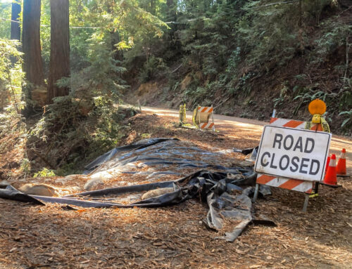
Planners discussed Segment 8 and Segment 9 of the Santa Cruz Branch Rail Line at a March 31 meeting. (Santa Cruz County Regional Transportation Commission)
Correction: Cost estimates of rail plans were incorrectly stated in an earlier version of this story.
SANTA CRUZ >> Rail trail project planners showed renderings and maps of two versions of the paved path from Santa Cruz to Live Oak during a public workshop on Thursday, March 31.
The images were the first to publicly detail Segment 8 and Segment 9 of the proposed path along the Santa Cruz Branch Rail Line. Thursday, leaders gathered input from a few dozen people so plans can be refined. Comments on Segments 8 and 9 are due April 15.
Segment 8 runs from Pacific Avenue and Beach Street in Santa Cruz to the east side of the San Lorenzo River bridge. Segment 9 runs along the rail line from the San Lorenzo River bridge past Murray Street, Simpkins Family Swim Center and on to 17th Avenue in Live Oak.
For Segment 9, planners have started designs for two possibilities:
- An “interim” plan that aims to temporarily remove the train tracks and build a path on the rail line.
- An “ultimate” plan that keeps the rail track and builds a path next to it.
An environmental impact report for the two versions of the rail trail on Segment 9 is due at the end of the year.
Segment 8: Pacific Avenue to the San Lorenzo River
Because the bike path was recently upgraded along Beach Street near the Santa Cruz Beach Boardwalk, relatively few major changes are proposed:
- A sidewalk island is proposed to accommodate picture takers near Beach Street and Riverside Avenue. It aims to keep people from standing on the bike path to take photos.
- More visible crosswalks are proposed on Beach Street where it crosses Riverside Avenue as well as Main, Westbrook and Cliff streets.
- Bike path upgrades are planned near the roundabout at Pacific Avenue and Beach Street.
Santa Cruz City Engineer Nathan Nguyen has said that some goals of the project are to add cyclists and walkers on the path and facilitate bike trips to schools and businesses. City planners are working with staff of the Santa Cruz County Regional Transportation Commission and RRM Design Group on Segment 8 plans.
No railroad tracks are proposed to be removed on Segment 8 and no upgrades are expected to the San Lorenzo bridge path that was widened to 10 feet in 2019, Nguyen and other engineers at the meeting said.

On Pacific Avenue in Santa Cruz, a green bike path is proposed to cross the railroad tracks perpendicular rather than its current angle. Arrows show where some cyclists said they wanted a safer connection from the bike path to the traffic circle. Notes are from residents’ suggestions during a March 31 workshop. (RRM Design Group)
Several participants said they wanted to improve the way westbound cyclists on the bike path enter the traffic circle at Beach Street and Pacific Avenue. They described “conflicts” with drivers as they tried to enter the roundabout. Better signs or a painted bike path could be changed in the plan, designers said.

A rendering shows a proposed sidewalk island to accommodate picture takers who often block a bike path near the Santa Cruz Beach Boardwalk. (RRM Design Group)

A rendering shows a new sidewalk island where photographers could stand away from the bike path. (RRM Design Group)
Segment 9: San Lorenzo River to 17th Avenue in Live Oak
From the San Lorenzo River to 17th Avenue, planners from the City of Santa Cruz, County of Santa Cruz and RRM Design Group discussed several proposals.
Two versions of the trail are proposed for the environmental impact report. The first is an “interim” plan with a paved path on the rail line, the second is an “ultimate” plan with a path parallel to the railroad.
- The “ultimate” path parallel to the railroad is narrower, about 10 to 12 feet wide, because of constraints with trees, hills, legal right-of-way and other factors, the engineers said. The “interim” path on the railroad can be wider, about 12 to 16 feet, because of fewer constraints.
- The “ultimate” path more expensive to build in the short term because it involves more raised platforms, retaining walls and other features, leaders said. The ultimate path on Segments 8 and 9 is projected to cost about $33.1 million, compared with about $18 million to build the the “first phase” of the interim path. The “second phase” of the interm plan is to demolish the trail on the tracks and build a path next to it, so the total cost of the interim plan is projected to be $57.4 million, planners said.
- On the rail bridge that spans the Santa Cruz Small Craft Harbor, a 10-feet-wide cantilevered bike bridge appears next to it in the “ultimate” plan. It’s similar to the bridge that was installed on the San Lorenzo River bridge, Nguyen said. The “interim” plan shows a path directly on top of the rail bridge.
- Removal of the railroad tracks in the interim plan is meant to be temporary, said Guy Preston, executive director of the Santa Cruz County Regional Transportation Commission. The idea is to return the rails for a passenger rail service years from now if money becomes available from the state or other sources.

Planners presented rough cost estimates of “interim” and “ultimate” trail plans during a March 31 meeting. (City of Santa Cruz)

Leaders described an “ultimate” plan, left, with a path parallel to the railroad tracks on Santa Cruz Branch Line Segment 9. An “interim” plan, right shows a paved path on where the railroad tracks now run. (RRM Design Group)
The “ultimate” and “interim” plans along Murray Street include new crosswalks and new stop signs for cyclists where the path crosses Mott and Seabright Avenues.

An “ultimate” plan, top, proposes a new crosswalk on Seabright Avenue. An “interim” plan, below, shows a path above where the railroad now runs. (RRM Design Group)
Some participants at Thursday’s meeting said the 10-feet-wide San Lorenzo bike bridge was wide enough to accommodate cyclists and walkers, while others said they wanted wider paths on the proposed Murray Street bridge.
A major crossing is where the path meets Seventh Avenue. Flashing lights are proposed in both plans to alert drivers of passing cyclists and walkers, Nguyen said.

Different path configurations were shown near a parking lot of Simpkins Family Swim Center. (RRM Design Group)
Engineers also emphasized safety in its proposed path options at 17th Avenue because of children who walk to nearby Shoreline Middle School. Flashing lights and advanced warnings for drivers are proposed, as well as a raised median so walkers can cross half the street at a time.

A rendering shows proposals of a path at 17th Avenue near Shoreline Middle School in Live Oak. The top image shows an “ultimate” path parallel to the railroad. The bottom image shows an “interim” path on the railroad. A raised median on 17th Avenue in both plans helps walkers cross one portion of the street at a time. (RRM Design Group)
To participate
Feedback on Segments 8 and 9 can be emailed to Santa Cruz City Engineer Nathan Nguyen by April 15.
Read more:
- Rail trail plans detailed from Santa Cruz to Aptos – Feb. 18, 2022
- Rail trail ballot measure outlined by Santa Cruz County staff – March 4, 2022
Santa Cruz Local’s news is free. Our newsroom relies on locals like you for financial support. Our members make regular contributions, starting at $19 a month or $199 year.

Stephen Baxter is a co-founder and editor of Santa Cruz Local. He covers Santa Cruz County government.